The first step in checking out these new pictures of Pluto is to first figure out what we're looking at. We can figure out what part of Pluto is visible. We can figure out where the satellite, Charon, will be and how far apart they are. We can also figure out how big they should be in the image. Once we know what to expect for Pluto, we then need to understand the actual images. HST is a spacecraft and doesn't know anything about "up" or "down" like we do here on Earth. That means the pictures can be rotated to just about any orientation. These steps of predicting and then understanding the pictures is called navigating.
Pluto at the time of the images.
From what we know about the orbit of Pluto around the Sun and the orbit of Charon around Pluto, here are a few details:
Distance from Sun          29.887 AU   (4,471,000,000 km)
Distance from Earth        29.689 AU   (4,441,000,000 km)
Pluto diameter              0.107 arc-seconds   (2300 km)
Charon diameter             0.055 arc-seconds   (1180 km)
Pluto-Charon separation     0.852 arc-seconds (18,335 km)
Sub-Earth latitude         19 degrees
Sub-Earth longitude       201 degrees
The unit arc-seconds is a measure of the angular size of an object. When you're standing outside where you can see the horizon, from one horizon to the other through the point directly overhead, that is 180 degrees or half a circle. Our own moon appears to be 0.5 degrees in diameter. The degree scale is chopped up into smaller bits just like time is. There are 60 arc-minutes in one degree and there are 60 arc-seconds in one arc-minute. That means our moon is 1800 arc-seconds in diameter, nearly 17,000 times as big as the apparent size of Pluto! Of course, our moon isn't really that much bigger. It only looks bigger because it is much, much closer.
The sub-Earth latitude and longitude are coordinates on the surface of Pluto. 0 degrees latitude would be on Pluto's equator. At 0 degrees longitude, Charon is directly overhead. If you were standing on Pluto at these coordinates, the Earth (and Sun) would be directly overhead. We can only see one half of the planet at a time and these coordinates tell us which half is visible.
The camera we are using takes pictures with little square picture element detectors called pixels. The format we used is a 512 by 512 pixel array. Each of these pixels measures 0.01435 arc-seconds across. Here's some more information about what we see in the images:
Full image width and height  7.4 arc-seconds
Pluto diameter               7.5 pixels
Charon diameter              3.8 pixels
Pluto-Charon separation     59.4 pixels
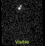
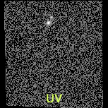
You can see from this that the area of the image we care about is only a tiny fraction of the entire image. So, we're looking for two small spots of light in the full image and that's just what we see.
You can see Pluto and Charon in these images, Pluto is the brighter of the two. The rest of the image is just noise, which just looks like random speckles.
Now that we know where Pluto and Charon are on the image, we can grab a smaller chunk of the image and blow it up to get a closer look. We also need to understand the orientation of Pluto on the picture. The following image provides a roadmap to what we're seeing:
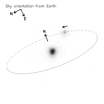
In the upper right hand corner is a "compass" that shows how this picture is oriented on our sky here on Earth and provides the familiar "up and down" directions. Pluto's axis of rotation is tipped on its side relative to our North (that's the direction of our own axis of rotation). The extra N arrow shows the direction of Pluto's north pole and axis of rotation in the picture. I use the definition of north that is based on the "right-hand rule" used in physics. To find "up" with the right-hand rule, you pretend you are holding the rotation axis in your right hand. Your thumb will point "up" and the curl of your fingers will point in the direction of rotation.
I've also drawn the path of the orbit of Charon around Pluto. This path is actually a circle but it looks like an ellipse because the path is tipped so Charon moves towards and away from us in the picture. The solid part of the path is where Charon is closer to us than Pluto and the broken curve is where Charon is further from Pluto than us. The small arrow above Charon show the direction of its motion.
Now, the navigation is essentially complete. There isn't much we can do with the image of Charon so you won't see this again in the following steps. Next we're off to looking in detail at the Pluto image.

Back to my home page,
Pluto page,
LFHST page,
Analysis Table of Contents.