Last updated: 11 May 2008
Weather conditions are highly variable. Winter highs can be near zero or as warm as the 60's, often sunny with snow on the ground, occasionally very windy. Summer mornings are often sunny and warm (70's or warmer), but afternoon thunderstorms (occasionally with hail) and cool breezes are common. Take water and good solar protection. Hikes #6 thru #8 involve some off-trail bushwhacking and should be attempted only by experienced hikers with good topo maps of the region. The environment is "montane", with ponderosa pines on south-facing slopes, lodgepole pine/Douglas fir on north-facing slopes, interspersed meadows, aspen groves, streams, rocky outcrops with views of both the Great Plains to the east and the snowy peaks of the Continental Divide to the west, red-rock spires, and the stream-fed, multi-pronged Gross Reservoir (Denver's water supply); jeep trails (some formally, but not totally effectively, closed to motorized traffic) provide the chief transportation routes, in addition to unmarked horse- and foot-trails. You are likely to encounter deer, elk, and a wide variety of birds. Black bears and large cats have been seen in the area (including by us). Beware of hunters (especially in autumn you should wear bright orange vests) and target-shooters.
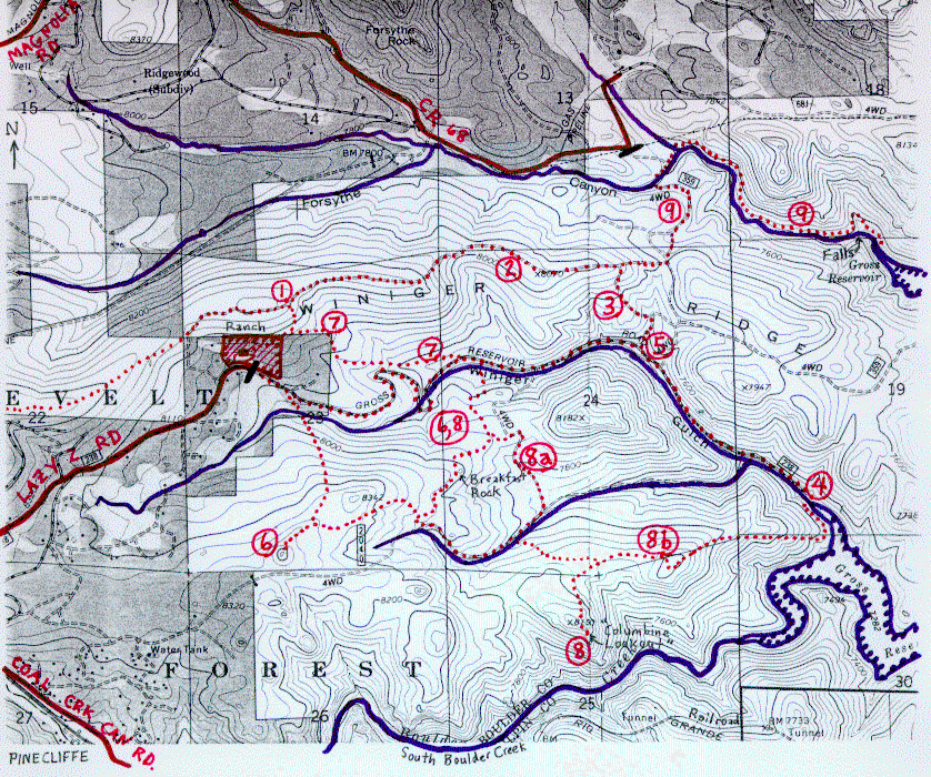
(1) SHORT WALK UP TO SEE THE DIVIDE. {Note: This route (not a trail) leaves from our house and is suggested only for our friends visiting at Rancho Europa. The public can readily scramble up to the trail along Winiger Ridge from points in public lands to the east: (a) walk through the gate at the end of Lazy Z; after 1/2 mile, at the loop to the north, join trail 7 and walk NW to where the trail peters out and scramble up to the top of the ridge near the first "I" in "WINIGER" on our map; (b) follow either the road or trail 7 to the east; 250 paces east of where trail 7 rejoins the road there are trails heading north, which peter out near the final "R" in "WINIGER" on our map, but you can continue scrambling north up to the saddle mentioned in #2 below.} Less than 10 minutes one-way, 15 min. roundtrip. From our ranch, proceed east-northeast toward the relatively low point on the horizon and cross through our fence near the posts at the NE corner of our property. Gradually curve around to the left (more to the north, to avoid descending into the valley to the east) and ascend the hill until you come to a prominent foot trail, which trends east-west along Winiger Ridge in front of the forest that covers the north-facing flank of the ridge. From this point, about a thousand feet northeast of our ranch house, you can see snow-covered peaks (and Eldora Ski Resort) to the west and towards James Peak to the southwest plus a glimpse of Mt. Evans to the south, and get a better view of Thorodin Mountain in Golden Gate State Park to the south. Descend by retracing your steps; alternatively walk 1000 feet west on the trail, then descend to our ranch house via the northwest corner of our property.
(2) WINIGER RIDGE HIKE TO INDIAN PEAKS VIEWPOINT. About 30 minutes (1.2 mile) one-way; 1 hour roundtrip. Follow directions above to the Winiger Ridge Trail. Upon reaching the trail, follow it to the right (east), where you enter an area that was intentionally burned by the Forest Service in autumn 1998. The trail is basically level for one-half mile, then it turns left (south) and descends to a saddle. Continue along the trail as it ascends a continuation of the ridge to the east. Before you get into the trees again, turn around and look at the Continental Divide (Indian Peaks) to the northwest. Return the way you came. (You can also descend to the south from the saddle -- follow an eroded jeep trail, which ends at the Winiger Gulch Haul Road; follow that west to the Ranch [see hike #3 below]...this provides a shorter version of the loop described next.)
(3) WINIGER RIDGE/WINIGER GULCH LOOP (LYnda calls this Paradisio Loop). About 3.5 miles, 1.5 hours roundtrip. Follow directions above to the Indian Peaks viewpoint. Continue east another quarter of a mile. The trail begins to descend abruptly toward a 4-wheel- drive road visible below, but which you won't quite reach. Soon, the trail branches. Take the right fork, which then descends steeply down to the south. After a quarter of a mile, you encounter the Winiger Gulch Haul Road in the bottom of a small canyon (the stream is on the far side of the road). Turn right and walk up the road (a gentle grade) to the ranch. First you encounter some impressive red-rock spires on the north side of the road. About half- way back to the ranch, the road follows a large S-shaped course, providing a variety of views. (To short-cut the S, see Hike #7, below.) Shortly after completing the S, a road sign indicates that you are entering private land (that of our neighbor to the east). You reach the southeast corner of our property a few hundred feet before the gate that marks the east end of Lazy Z Road. Our ranch house is beyond (west) of the gate.
(4) WINIGER GULCH TO GROSS RESERVOIR. About 2 miles, 1 hour one-way (2 hours roundtrip). Follow Lazy Z Road east from the gate in front of our ranch. See description of the first half of the route in the description of the return part of hike #3 above. Follow the road, which keeps to the left side of the stream, all the way to one arm of Gross Reservoir. The level of the lake can vary by a hundred feet or more. When low, we could ascend the cleared slopes to the left, and have a wonderful view of South Boulder Creek cascading down to the lake. At other times, this section of the Creek is simply another arm of the reservoir. Return the way you came.
(5) COMBO: WINIGER RIDGE AND GROSS RESERVOIR. About 4.5 miles (2.5 hours) roundtrip. Follow directions for the "Loop" above, except turn left (instead of right) where the steep trail meets the Gulch Road. See hike #4 for description of the Reservoir. Return back up the Gulch road as described in #3 and #4 above.
(6) HIKE TO THE KNOB ACROSS FROM OUR RANCH. About 2 miles (2 hours) up; about 1 hour back the same way, 30 minutes if you bushwhack more directly back to the ranch. Hike down the road below our ranch toward the Reservoir, or take the trail described in hike #7. Soon after the end of the "S" [see hike #3 above], or 65 paces east of the trail described in #7, look for a jeep trail to the right, which crosses the Gulch stream and ascends the south side of the canyon rather steeply. Toward the top of the ridge (a quarter mile), the jeep trail forks; take the right fork toward the west [the east fork is described in hike #8]. After a prominent rock outcrop on the lefthand side of the trail ("Breakfast Rock", from which there is a view of our ranch with the Indian Peaks behind), the trail levels out, with nice views across a valley and beyond to Wondervu. After passing through a stand of young aspen, the road forks. [The lefthand fork is described in hike #8.] Take the righthand fork uphill toward the north; it curves around to the west and levels out near a rocky hill to the north. The goal, however, is the rocky hill (knob) ahead of you, to the west. As the jeep trail begins to dip and veer to the southwest, leave the trail and strike west a few hundred feet to the crest of a ridge that connects the two rocky hills, and follow it toward the hill. (If you were to stay on the trail, you would eventually end at a gate to private property in Pinecliffe west of the rocky knob.) Ascend the eastern side of the hill (easy route). There is half an acre of flat terrain on top (8500 ft. elevation, about 750 ft. climb from the stream crossing), with splendid views 360 degrees. Our ranch house is prominently visible to the north; there is a panorama of the Continental Divide from Rocky Mountain National Park south to James Peak. The mountains of Golden Gate State Park form the skyline to the south and a part of Gross Reservoir can be seen to the west.
Return the way you came, if you wish. A more direct bushwhack is much faster, and not too difficult (but do not attempt if not experienced with off-trail hiking). (The goal is to circumvent, to the east, private property and the house that is between the hill and our ranch.) Return down the hill the way you ascended, and proceed back along the ridge toward the rocky hill to the northeast until you come to the low point, halfway between the two hills. Then proceed downhill, toward the north-northeast, in the direction of the rocky Twin Sisters Peaks in the middle background. Curve around to the north and then northwest as you approach the Winiger Gulch stream (the thicket near the stream is not too dense); jump across it, and proceed northwest up across meadows to the Gulch Haul Road (Lazy Z extension) near the southeast corner of our ranch.
(7) PRETTY SHORT-CUT TO THE EAST ("Blue Rug Trail"). [Do not attempt if not experienced with off-trail hiking.] The most direct route (for our friends: members of the public please access this trail as described in the boldfaced note in #1) to the east begins on a very obscure trail (basically a route) about 20 feet north of our dining room window; it proceeds east-north-east to a point fifty feet south of the posts marking the northeast corner of our ranch (as in #1). From this point, trend northeast passing just to the right of the low rock outcrops, until you encounter (in a couple hundred feet) an old jeep trail that goes eastward, mostly following a contour, but trending slightly downhill. It soon reaches a more prominent jeep trail that drops down to the southeast. (Ascending, this otherwise unremarkable intersection is noted when the major jeep trail ascends more steeply and turns northeast towards some rock outcrops with a Y-shaped twig jutting out of them, instead of continuing northwest, for the first time; there is a gap in the vegetation between a 10-foot pine tree and some shrubs.) A few hundred feet down, the trail branches in a pretty region of woods, columbine (in the early summer), and rock outcrops. Take the lefthand fork to the east (the righthand fork goes into private property). The trail soon comes close to part of the S-curve portion of the Gulch Haul Road, but continue on the trail. There is a short steep section, after which the trail passes through a pretty meadow (burned to the north in autumn 1998) and then ends at the Haul Road (just east of the end of the S-curve), 65 paces west of the intersection with the jeep trail that crosses the stream to the south. This is our recommended route to the jeep trail, Gross Reservoir, and other points southeast. The upper parts of the trail, near our ranch, may be difficult to locate, especially with snow cover, in which case the Haul Road is a more reliable route. (250 paces farther east from the jeep trail intersection, there is a prominent trail junction on the north side of the Haul Road. It goes most, but not all, of the way to the top of a high point on Winiger Ridge west of the saddle. A bit further east on the Haul Road is a lesser jeep trail on the north that actually ascends to the saddle, although the intersection is not visible from the Winiger Ridge trail where it crosses the saddle.)
(8) "COLUMBINE LOOKOUT": SPECTACULAR ROCKY OUTCROP WITH VIEWS OF THE DIVIDE, SOUTH BOULDER CREEK RAPIDS, SOUTHERN PACIFIC R.R. TUNNELS, AND GROSS RESERVOIR. WITH OPTIONAL RETURNS THROUGH A BEAUTIFUL MEADOW OR VIA GROSS RESERVOIR. Our favorite hike in the neighborhood, if you have a few hours. (About 2 hours up, 1.5 hours back, not counting view stops. Add at least one hour if you return via Gross Reservoir. Most of the hike is on jeep trails, but a short part is bushwhack; the return via Gross Reservoir involves 0.8 mile additional off-trail.) Take hike #7 east to the Winiger Gulch Haul Road. 65 paces to the east, bear right on the jeep trail, cross the creek, and proceed south up to the ridge, bearing right (west) at the fork just before the ridge crest. Turn right at the ridge crest, proceed west-southwest past a rocky outcrop (we call it "Breakfast Rock"), then through an aspen grove, to a trail juncture just past a slight crest. It is here that hike #6 turns right; instead, bear left, downhill toward the southeast, then east, scrambling around some fallen logs in the road. There is a small stream to the right of the jeep trail (a tributary is sometimes in the road itself). Turn right when a branching jeep trail crosses the stream (steep and slippery here), and walk up the trail for about 7 minutes until you reach a 500-foot-long level section. After that, when the trail suddenly starts descending for the first time, stop. This is what we call Reservoir Junction.
Retrace your steps 50 paces. From this point, a much less-used jeep trail proceeds perpendicularly toward the southwest. (Do not attempt the next portion if not experienced with off-trail hiking.) After about 100 paces along this route (near a stump at the righthand side of the trail), you will have circumvented the head of a small valley to the left and can proceed perpendicularly to this trail toward the southeast, aiming for the lefthand side of the prominence in front of you (Columbine Lookout). Ascend this rocky edifice from the north, angling up toward the southwest, then proceed to the highest point, at its southeast end. From here (8150 ft. elevation), you can see the Divide to the west, South Boulder Creek rapids below to the southwest, the town of Wondervu with Thorodin Mountain beyond to the south, the railroad tracks and tunnels of the Southern Pacific below Wondervu, several parts of Gross Reservoir below to the east, and the Great Plains beyond. Return the way you came, or by one of the two alternate routes below.
(8a) RETURN FROM COLUMBINE LOOKOUT VIA MEADOW. (About the same length as on your ascent.) Return to the creek crossing, turn right, then continue down the jeep trail to the east-southeast. It soon veers east-northeastward across a beautiful valley meadow, then ascends a ridge and curves left, to the west. Shortly thereafter, the jeep trail forks. Take the major fork to the right, which soon reaches the fork just before the ridge crest described on the ascent. Return via Winiger Gulch Haul Road or the shortcut (#7).
(8b) LONGER RETURN FROM COLUMBINE LOOKOUT VIA GROSS RESERVOIR. [Note: this route adds at least an hour and involves nearly a mile of off-trail hiking. Take a topo map.] Return to Reservoir Junction [described in #8 above]. Follow the jeep trail down to the southeast. Alternatively (to avoid elevation change), turn northeast at this junction and follow an old, ill-defined jeep trail through the trees, then parallel the crest of a ridge to the east-northeast until you reconnect with the jeep trail. The jeep trail ascends the top of a small hill, from which you can see Columbine Lookout to the southwest, and also our ranch-house to the west-northwest, set beneath Winiger Ridge with the snowy Indian Peaks beyond.
From the top of the hill, proceed downslope east-northeast through a thin forest. Try to keep just southeast of the downward-sloping ridge crest (flank of the hill), which will let you cross meadows periodically; gradually keep to the right (more due east). At one point, there is a steep drop to a meadow "step". (From many of these places, there are beautiful views of arms of Gross Reservoir.) A few more giant "steps" down, mostly through meadows (be sure to aim left of the point of land sticking west into Gross Reservoir ahead) brings you to a trail, which circumvents the reservoir about 100 feet above its high-water mark. Follow this trail to the left, which eventually brings you through thick foliage to a point just west of the end of the lake, where you can hop across Winiger Gulch stream and get to the Winiger Gulch Haul Road near its terminus. Return west on the Haul Road (see hike #3), perhaps taking the shortcut before the S-curve, described in hike #7.
(9) WATER FALLS IN FORSYTHE CANYON AND GROSS RESERVOIR (FOREST TRAIL 852). A water-lovers trail, with the constant sound of a tumbling creek, a lovely waterfalls, ending at an arm of the reservoir. About 5 miles (4 hours) round-trip. (Alternatively, drive 6 miles from our ranch along Lazy Z, Magnolia, and CR68 to parking spot marked by "Gate Ahead: Turn Around Here" sign and "Road Closed to Protect Wildlife" gate, and hike only the final mile to the reservoir. If the gate is open and you have a high-clearance vehicle, drive in 1000 feet to the turn-off marked "Trail 852" and park there.)
From the ranch, follow hike #2 to Indian Peaks viewpoint; continue (as on hike #3, but do NOT take branch to right) and descend steeply to prominent jeep road. Bear left (north); jeep road immediately branches -- righthand (easterly) branch is steeper but shorter. Soon after branches reconnect, there is an intersection of several jeep trails and a hiking trail. The foot trail that branches right from the NNW-trending branch of the jeep trail provides direct access to Forsythe Canyon; or continue taking the main (NNW) jeep road down past a U-curve that crosses Forsythe stream; take the first turn-off to the right. A hundred feet along the turn-off is a sign for "Trail 852"; just beyond is a parking area, again labelled as the 852 trailhead (this place is just a thousand feet southeast of the parking spot along CR68, within the closed-to-protect-wildlife area). The well-marked trail proceeds to cross, on a small footbridge, a tributary stream; bear right at the signs, just before a tall blue spruce. Hereafter, the trail is well-used but overgrown where it traverses a couple of meadows. It follows along the north side of Forsythe stream (always 5 to 100 feet away) through a cool, verdant, mixed conifer/deciduous forest in the bottom of Forsythe Canyon. After half-a-mile, you reach the head of a lovely waterfalls with about a 35 foot drop. The trail circumvents the falls to the north, then returns to near the base of the falls before proceeding the final several hundred feet to where the stream empties into an arm of Gross Reservoir. (To get to the plunge pool at the base of the falls, take the first backwards branching fork in the trail after the diversion, heading toward a tall tree with reddish trunk; be careful of slippery, sloping rock ledges near the falls.) You can walk (easily) only a few hundred feet along the south shore of the reservoir at this point; it looks as though it is easier to walk along the north shore about a thousand more feet to where you can look out across a much broader expanse of water. Return the way you came.
 Clark and Lynda's Web Site.
 Homepage