Monday, February 16, 2004 Last modifiedFriday, June 13, 2003 11:16 PM PDT
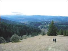
Allen Throop/Venture contributor Hikers get a picturesque view of Marys Peak to the west from Beazell Memorial Forest, near Kings Valley.
Heavenly habitat
New Beazell Memorial Forest is culmination of a family's dream
By ALLEN THROOP venture contributor
KINGS VALLEY — The owl sat patiently in the tree as if aware of our scrutiny.
The
bird seemed eager to display its characteristic features as four
birdwatchers alternately peered through binoculars and checked field
guides.
First we noticed the distinctive profile and the
prominent black streaks on the belly; next, someone spotted the long
tail jerked prominently to the side.
Finally, as the owl turned, we located the eye-like spots on the back of its head.
As
we agreed that we were watching a Northern pygmy owl, the bird got
tired of the game and flew away. We then shifted our attention from the
oak tree in the field in front of us to Marys Peak on the western
horizon.
We were enjoying a beautiful day near the high point of
Benton County's newest public open space, the 586-acre Beazell Memorial
Forest. The property contains a wide variety of habitats including
riparian areas along Plunkett Creek, oak savannas, Douglas fir forests
and grassy hilltop meadows.
Fred and Dolores Beazell were not
well-known in the county while they were living. They moved to the
property after Fred retired from his California job in 1989 to live
quietly in their Kings Valley home.
Since I had the privilege of
knowing Fred Beazell, I'm excited to see his dream of turning the
property into a county forest come true.
Soon after I was
introduced to Fred, I realized that ill health prevented him from
giving his dog Fritzie much exercise. Fritzie and I became friends as
we explored the far corners of the property.
My favorite hike was to head up to a grassy bald that can't be seen from the road.
From
Fred's house, the dog and I would head out through some of the
abandoned pastures that he had planted with fir trees. We then passed
among large oak trees that had been over-topped by Douglas firs.
As
the hill grew steeper, the oaks gave way to pure fir forest. After
working our way through some serious poison oak, we came to the bottom
of a long, steep, grassy meadow.
Occasionally, I would stop to
catch my breath and enjoy the view, at first no more than the tree
canopy behind us. As we climbed higher, I could peer down into a steep
drainage to the north or look at the forest-covered hillside across the
valley.
Finally, from the top of the bald I could see Kings
Valley beneath me and Marys Peak on the skyline. Fritzie would
disappear into the grass exploring his own world but occasionally come
back to see that I was OK.
Beginning in 1966, the Beazells bought cut-over forestland and abandoned pastures.
Fred
had a passion for planting trees. As he planted more and more trees,
Fred began to picture the old-growth forest that could evolve on his
land.
Charlie Ross, a former Oregon State University extension
forester and visionary behind the protected open spaces around
Corvallis, nurtured the idea of leaving the Beazell Forest as a
memorial to Fred's wife, Dolores.
Fred and Jerry Davis, director
of Benton County's Open Space and Parks Department, worked out details
for a self-sustaining forest managed primarily to promote healthy
diversity while generating sufficient revenue through timber harvests
to maintain the forest, a day-use area and trails.
Since Fred's
death in 2000, Benton County Open Space and Parks Department has been
busy trying to fulfill his vision. They have documented the condition
of existing vegetation, wildlife, and streams; developed a management
plan for the property; stabilized deteriorating buildings; and
undertaken preparations for public use of the site.
On arrival,
visitors will first see the Plunkett house, one of the oldest dwellings
in Kings Valley. The exterior has been restored to its approximate
appearance prior to 1900.
Behind the house is a massive barn
constructed in the 1930s using logs cut on the property. Plans call for
using the barn as an education center. An old orchard south of the barn
is one more reminder of the years the Plunkett family labored to farm
the land.
Restrooms, a parking lot, drinking fountain, picnic tables and an information kiosk now nestle between the two buildings.
New trails give visitors access to much of the property. More are planned.
A
picturesque curved wooden bridge upstream from the barn leads to a
junction of two gentle trails. To the right, a trail leads up Plunkett
Creek along an old logging road.
Solitude characterizes this
trail now as light filters down through big-leaf maples. With time, a
re-grown forest now masks evidence of the chainsaws, bulldozers, and
log trucks that once echoed through the valley.
Other trails will eventually branch from the old road toward the hilltops on both sides of the valley.
The
trail to the left from Plunkett Creek Bridge follows the old road
almost to the highway. At the junction with the lane to the Beazell
house (currently occupied by a caretaker and not open to the public),
the trail enters a meadow.
This trail — the Bird Loop — starts
in a second-growth forest where overgrown fences give mute testimony to
the long-gone pastures and the cattle that once grazed here. A round
trip on either of these first two trails is about 1¼ miles long.
Two trails also go to the south.
A
half-mile interpretive trail will be a showplace of land management on
the property. The trail follows a road built in the summer and
reclaimed before the winter rains came, which allowed construction with
no culverts, ditches, or gravel.
Two years ago, the trees
adjacent to the road were so dense that no sunlight reached the barren
forest floor. After thinning, the more open forest will allow faster
tree growth and a diversity of vegetation and wildlife beneath the
trees.
In places, fir trees, which were shading out the older
but smaller oaks, have been killed to encourage the oaks. Some firs
were topped to become wildlife trees.
Income from sale of the
timber removed, dedicated to upkeep of the property, will allow Beazell
Forest to be operated at no cost to Benton County taxpayers.
The
South Loop Trail is steeper and, at over two miles, longer than the
others. The route passes through the area covered by the interpretive
trail, reaches a large bald, continues across the meadow into more
trees and makes a loop over a ridge top.
Trees were cut along the ridge allow a view over Plunkett Creek to the rest of the property and out into Kings Valley.
Near
the overlook, three or four large fir trees stand in stark contrast to
Fred's surrounding plantings. Someday I hope to learn the story of
those gnarled giants.
Beazell Forest opens to the public on July
1, with grand opening ceremonies scheduled for 10 a.m. to 2 p.m. on
July 26. The Forest is located near Kings Valley on state highway 223
approximately five miles north of Wren. The entrance, on the east side
of the highway, is marked with a new wooden fence and sign.