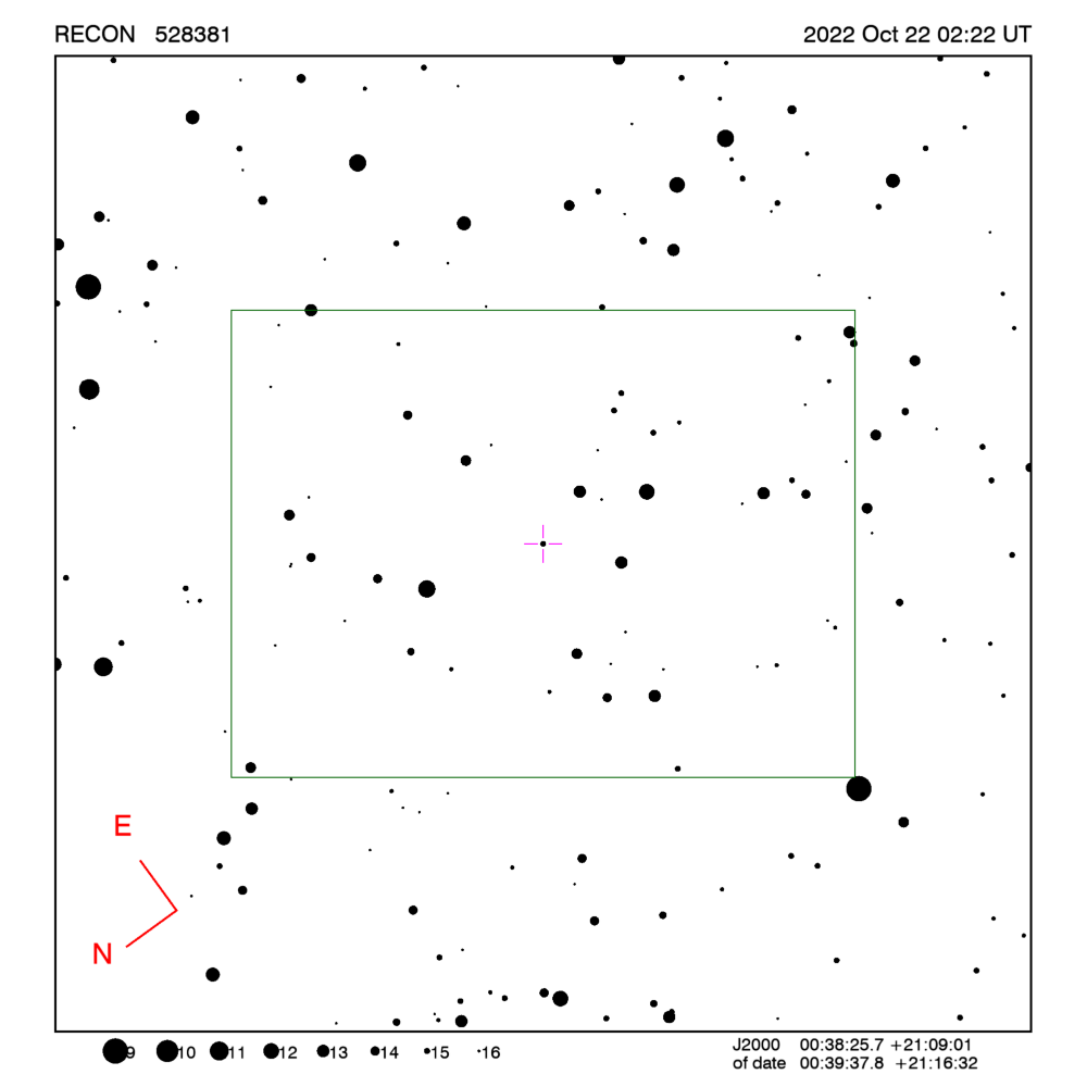
RECON: TNO occultation with 528381
Event between (528381) 08ST291 and star GA1100:00077570
with event index number of 2136855
Geocentric closest approach at 2022/10/22 02:22:38 UTC
J2000 position of star is 00:38:25.7 +21:09:01
Equinox of date position of star is 00:39:37.6 +21:16:31
Stellar brightness G=15.5,
use SENSEUP=128 with the MallinCam and and exposure
time of 2 seconds with the QHY174 camera.
Star is 145 degrees from the moon.
Moon is 12% illuminated.
TNO apparent brightness V=22.3
 [RECON map]
TNO is 62.8 AU from the Sun
and 61.8 AU from the Earth.
The TNO is moving 25.5
km/sec on the sky relative to the star, or,
2.0 arcsec/hr.
The 1-sigma error in the time of the event is 136 seconds.
The 1-sigma cross-track error in the shadow position is
3390 km.
The sky-plane scale is
44835.3 km/arcsec.
The TNO has an absolute magnitude Hv=4.3
Diameter=824.2 km assuming a 5% albedo -- 32.8 sec chord
Diameter=336.5 km assuming a 30% albedo -- 13.4 sec chord
Dynamical classification is 6:1EEEEE
Star training set for 528381, (2022/10/22 02:22UT)
Object            RA         Dec     mag  sep  mel
Deneb          20:42:12.6 +45:21:46  1.3 53.71 115
Algenib        00:14:24.8 +15:18:37  2.8  8.45 153
55 Psc         00:41:07.9 +21:33:47  6.4  0.45 144
PPM 089987     00:38:52.9 +21:13:29  7.8  0.18 145
528381         00:39:37.8 +21:16:32 15.5       144
Positions are for equinox of date
This table contains the target star visibility for the RECON
network. The observing range has been set to a maximum of
5.0 sigma about the mid-time.
The median site spacing is 33.6 km
RECON observability=0.4 and success probability=0.0%
| Site |
Site mid-time
(UT) |
Sun alt
(deg) |
Sky |
Moon |
Star alt
(deg) |
Star az
(deg) |
Target |
Observing Time
(UT) |
X-track
(km) |
| Victoria |
02:23:55 |
-12.5 |
AT |
Down |
31.1 |
92.6 |
Up |
02:12:07 - 02:35:42 |
17482 |
| Kamloops |
02:23:30 |
-14.4 |
AT |
Down |
32.8 |
96.3 |
Up |
02:11:42 - 02:35:17 |
17466 |
| Peachland |
02:23:30 |
-14.8 |
AT |
Down |
33.3 |
96.2 |
Up |
02:11:42 - 02:35:17 |
17411 |
| Kelowna |
02:23:30 |
-15.0 |
AT |
Down |
33.5 |
96.5 |
Up |
02:11:42 - 02:35:17 |
17404 |
| Summerland |
02:23:48 |
-14.9 |
AT |
Down |
33.4 |
96.2 |
Up |
02:12:01 - 02:35:36 |
17395 |
| Penticton |
02:23:49 |
-15.0 |
AT |
Down |
33.5 |
96.3 |
Up |
02:12:01 - 02:35:36 |
17388 |
| Oliver |
02:23:50 |
-15.0 |
AT |
Down |
33.5 |
96.1 |
Up |
02:12:02 - 02:35:37 |
17374 |
| Anarchist Mountain Observatory |
02:23:50 |
-15.1 |
AT |
Down |
33.7 |
96.1 |
Up |
02:12:03 - 02:35:38 |
17360 |
| Tonasket |
02:23:52 |
-15.1 |
AT |
Down |
33.7 |
95.8 |
Up |
02:12:04 - 02:35:39 |
17349 |
| Okanogan |
02:23:52 |
-15.0 |
AT |
Down |
33.6 |
95.5 |
Up |
02:12:05 - 02:35:40 |
17340 |
| Manson/Chelan |
02:23:56 |
-14.6 |
AT |
Down |
33.3 |
94.7 |
Up |
02:12:08 - 02:35:43 |
17340 |
| Brewster |
02:23:53 |
-14.9 |
AT |
Down |
33.5 |
95.2 |
Up |
02:12:06 - 02:35:41 |
17336 |
| Wenatchee |
02:23:57 |
-14.5 |
AT |
Down |
33.2 |
94.3 |
Up |
02:12:10 - 02:35:45 |
17326 |
| Ellensburg |
02:23:59 |
-14.4 |
AT |
Down |
33.1 |
93.9 |
Up |
02:12:12 - 02:35:47 |
17316 |
| Yakima |
02:24:01 |
-14.3 |
AT |
Down |
33.1 |
93.6 |
Up |
02:12:14 - 02:35:49 |
17298 |
| Toppenish/White Swan |
02:24:02 |
-14.5 |
AT |
Down |
33.3 |
93.6 |
Up |
02:12:14 - 02:35:49 |
17282 |
| The Dalles |
02:24:06 |
-13.9 |
AT |
Down |
32.8 |
92.5 |
Up |
02:12:18 - 02:35:53 |
17276 |
| Goldendale |
02:24:03 |
-14.2 |
AT |
Down |
33.0 |
92.9 |
Up |
02:12:16 - 02:35:51 |
17273 |
| Maupin |
02:24:07 |
-14.0 |
AT |
Down |
32.9 |
92.3 |
Up |
02:12:20 - 02:35:55 |
17253 |
| Sisters |
02:24:10 |
-13.6 |
AT |
Down |
32.5 |
91.4 |
Up |
02:12:23 - 02:35:58 |
17230 |
| Bend |
02:24:12 |
-13.8 |
AT |
Down |
32.7 |
91.5 |
Up |
02:12:24 - 02:35:59 |
17209 |
| PNWRO |
02:24:02 |
-15.5 |
AT |
Down |
34.3 |
94.5 |
Up |
02:12:15 - 02:35:50 |
17209 |
| Oregon Observatory |
02:24:12 |
-13.7 |
AT |
Down |
32.7 |
91.2 |
Up |
02:12:25 - 02:36:00 |
17206 |
| Chiloquin |
02:24:18 |
-13.3 |
AT |
Down |
32.4 |
90.1 |
Up |
02:12:30 - 02:36:05 |
17157 |
| North Lake |
02:24:15 |
-14.1 |
AT |
Down |
33.1 |
91.2 |
Up |
02:12:27 - 02:36:02 |
17153 |
| Klamath Falls |
02:24:19 |
-13.4 |
AT |
Down |
32.4 |
90.0 |
Up |
02:12:31 - 02:36:06 |
17136 |
| Lakeview |
02:24:18 |
-14.4 |
AT |
Down |
33.5 |
90.9 |
Up |
02:12:31 - 02:36:06 |
17078 |
| Fall River/Burney |
02:24:23 |
-13.6 |
AT |
Down |
32.7 |
89.5 |
Up |
02:12:36 - 02:36:11 |
17060 |
| Cedarville |
02:24:22 |
-14.6 |
AT |
Down |
33.7 |
90.6 |
Up |
02:12:34 - 02:36:09 |
17036 |
| Sleaford |
02:23:25 |
-23.2 |
Dark |
Down |
41.3 |
110.2 |
Up |
02:11:37 - 02:35:12 |
17013 |
| Susanville |
02:24:25 |
-14.2 |
AT |
Down |
33.3 |
89.6 |
Up |
02:12:38 - 02:36:13 |
16996 |
| Greenville |
02:24:27 |
-13.9 |
AT |
Down |
33.1 |
89.2 |
Up |
02:12:39 - 02:36:14 |
16993 |
| Gimple |
02:24:26 |
-14.0 |
AT |
Down |
33.1 |
89.3 |
Up |
02:12:39 - 02:36:14 |
16990 |
| Quincy |
02:24:27 |
-13.9 |
AT |
Down |
33.1 |
89.1 |
Up |
02:12:40 - 02:36:15 |
16982 |
| Portola |
02:24:27 |
-14.3 |
AT |
Down |
33.4 |
89.3 |
Up |
02:12:40 - 02:36:15 |
16956 |
| Reno |
02:24:29 |
-14.8 |
AT |
Down |
34.0 |
89.5 |
Up |
02:12:42 - 02:36:17 |
16914 |
| Carson City |
02:24:29 |
-14.8 |
AT |
Down |
34.0 |
89.3 |
Up |
02:12:42 - 02:36:17 |
16893 |
| Gardnerville |
02:24:30 |
-14.8 |
AT |
Down |
34.0 |
89.2 |
Up |
02:12:42 - 02:36:17 |
16877 |
| Yerington |
02:24:29 |
-15.3 |
AT |
Down |
34.5 |
89.6 |
Up |
02:12:42 - 02:36:17 |
16855 |
| Hawthorne |
02:24:31 |
-15.7 |
AT |
Down |
34.9 |
89.6 |
Up |
02:12:43 - 02:36:18 |
16806 |
| Lee Vining |
02:24:33 |
-15.3 |
AT |
Down |
34.5 |
88.9 |
Up |
02:12:46 - 02:36:21 |
16794 |
| Bishop |
02:24:34 |
-15.8 |
AT |
Down |
35.1 |
88.9 |
Up |
02:12:47 - 02:36:22 |
16727 |
| Tonopah |
02:24:31 |
-16.8 |
AT |
Down |
36.0 |
90.1 |
Up |
02:12:44 - 02:36:19 |
16718 |
| Beatty |
02:24:34 |
-17.1 |
AT |
Down |
36.4 |
89.6 |
Up |
02:12:47 - 02:36:22 |
16627 |
| Indian Springs |
02:24:34 |
-18.0 |
AT |
Down |
37.2 |
90.0 |
Up |
02:12:47 - 02:36:22 |
16559 |
| Wildwood |
02:24:46 |
-15.6 |
AT |
Down |
34.8 |
86.6 |
Up |
02:12:59 - 02:36:34 |
16534 |
| Henderson |
02:24:37 |
-18.6 |
Dark |
Down |
37.8 |
90.0 |
Up |
02:12:49 - 02:36:24 |
16494 |
| Idyllwild |
02:24:47 |
-17.1 |
AT |
Down |
36.3 |
87.3 |
Up |
02:13:00 - 02:36:35 |
16425 |
| Laughlin/Bullhead City |
02:24:40 |
-18.9 |
Dark |
Down |
38.1 |
89.5 |
Up |
02:12:53 - 02:36:28 |
16419 |
| Patrick |
02:24:38 |
-19.5 |
Dark |
Down |
38.7 |
90.1 |
Up |
02:12:50 - 02:36:25 |
16403 |
| Mohave Valley |
02:24:40 |
-18.9 |
Dark |
Down |
38.1 |
89.3 |
Up |
02:12:52 - 02:36:27 |
16401 |
| Kingman/Dolan Springs |
02:24:38 |
-19.3 |
Dark |
Down |
38.5 |
89.8 |
Up |
02:12:51 - 02:36:26 |
16397 |
| Lake Havasu City |
02:24:40 |
-19.1 |
Dark |
Down |
38.3 |
89.1 |
Up |
02:12:53 - 02:36:28 |
16363 |
| Parker |
02:24:42 |
-19.1 |
Dark |
Down |
38.4 |
88.9 |
Up |
02:12:54 - 02:36:29 |
16339 |
| Calipatria |
02:24:46 |
-18.1 |
Dark |
Down |
37.3 |
87.5 |
Up |
02:12:59 - 02:36:34 |
16329 |
| Dunrhomin |
02:24:07 |
-25.9 |
Dark |
Down |
45.0 |
100.3 |
Up |
02:12:19 - 02:35:54 |
16317 |
| CU-SBO |
02:24:09 |
-25.9 |
Dark |
Down |
45.0 |
100.0 |
Up |
02:12:21 - 02:35:56 |
16306 |
| Yuma |
02:24:47 |
-18.8 |
Dark |
Down |
38.0 |
87.6 |
Up |
02:13:00 - 02:36:35 |
16258 |
| George/Scottsdale |
02:24:40 |
-21.2 |
Dark |
Down |
40.4 |
89.9 |
Up |
02:12:53 - 02:36:28 |
16196 |
Azimuth is measured in degrees eastward from north.
North is at an azimuth of 0, due East is at an azimuth
of 90 degrees, due South is 180, and due West is 270.
Do not use the listing below for the RECON CPC 1100 telescopes.
This is provided for other non-team facilities.
Star training set for 528381, (2022/10/22 02:22UT)
Object            RA         Dec     mag  sep  mel
Deneb          20:41:25.9 +45:16:49  1.3 53.71 115
Algenib        00:13:14.2 +15:11:01  2.8  8.45 153
55 Psc         00:39:55.6 +21:26:17  6.4  0.45 144
PPM 089987     00:37:40.8 +21:05:59  7.8  0.18 145
528381         00:38:25.7 +21:09:01 15.5       145
Positions are for J2000
Event circumstances last updated at 2022/10/03 04:11:49 UT
Marc W. Buie,
Southwest Research Institute
RECON