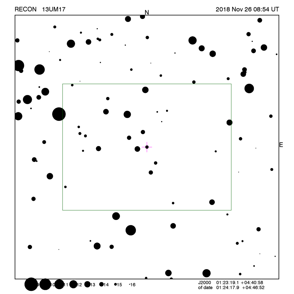
RECON: TNO occultation with 13UM17
Event between 13UM17 and star GA0940:00121980
with event index number of 220111
Geocentric closest approach at 2018/11/26 09:32:53 UTC
J2000 position of star is 01:23:19.1 +04:40:58
Equinox of date position of star is 01:24:17.7 +04:46:50
Stellar brightness G=15.5,
use SENSEUP=128
Star is 85 degrees from the moon.
Moon is 87% illuminated.
TNO apparent brightness V=24.0
 [RECON map]
TNO is 41.9 AU from the Sun
and 41.2 AU from the Earth.
The TNO is moving 17.4
km/sec on the sky relative to the star, or,
2.1 arcsec/hr.
The 1-sigma error in the time of the event is 484 seconds.
The 1-sigma cross-track error in the shadow position is
3594 km.
The sky-plane scale is
29845.0 km/arcsec.
The TNO has an absolute magnitude Hv=7.7
Diameter=176.2 km assuming a 5% albedo -- 10.1 sec chord
Diameter=71.9 km assuming a 30% albedo -- 4.1 sec chord
Dynamical classification is CLASSICAL
Star training set for 13UM17, (2018/11/26 09:33UT)
Object            RA         Dec     mag  sep  mel
Fomalhaut      22:58:41.5 -29:31:18  1.2 48.94 128
68Omi Cet      02:20:18.2 -02:53:34  2.0 15.96  75
PPM 144619     01:27:52.3 +03:37:58  6.5  1.45  85
PPM 144527     01:23:42.3 +04:50:11  7.5  0.16  85
13UM17         01:24:17.9 +04:46:52 15.5        85
Positions are for equinox of date
This table contains the target star visibility for the RECON
network. The observing range has been set to a maximum of
1.9 sigma about the mid-time.
The median site spacing is 31.8 km
RECON observability=0.5 and success probability=9.3%
| Site |
Site mid-time
(UT) |
Sun alt
(deg) |
Sky |
Moon |
Star alt
(deg) |
Star az
(deg) |
Target |
Observing Time
(UT) |
X-track
(km) |
| Kelowna |
09:27:55 |
-54.6 |
Dark |
Up |
18.2 |
255.1 |
Really Low |
09:12:55 - 09:42:55 |
2554 |
| Summerland |
09:27:55 |
-54.8 |
Dark |
Up |
18.5 |
254.8 |
Really Low |
09:12:55 - 09:42:55 |
2552 |
| Penticton |
09:27:54 |
-54.9 |
Dark |
Up |
18.4 |
255.0 |
Really Low |
09:12:54 - 09:42:54 |
2520 |
| Okanagan Falls |
09:27:53 |
-55.1 |
Dark |
Up |
18.5 |
255.1 |
Really Low |
09:12:53 - 09:42:53 |
2502 |
| Oliver |
09:27:53 |
-55.2 |
Dark |
Up |
18.5 |
255.1 |
Really Low |
09:12:53 - 09:42:53 |
2486 |
| Anarchist Mountain Observatory |
09:27:52 |
-55.2 |
Dark |
Up |
18.5 |
255.3 |
Really Low |
09:12:52 - 09:42:52 |
2468 |
| Oroville |
09:27:52 |
-55.3 |
Dark |
Up |
18.5 |
255.3 |
Really Low |
09:12:52 - 09:42:52 |
2461 |
| Tonasket |
09:27:52 |
-55.5 |
Dark |
Up |
18.6 |
255.4 |
Really Low |
09:12:52 - 09:42:52 |
2438 |
| Okanogan |
09:27:51 |
-55.8 |
Dark |
Up |
18.8 |
255.4 |
Really Low |
09:12:51 - 09:42:51 |
2406 |
| Brewster |
09:27:51 |
-56.1 |
Dark |
Up |
19.0 |
255.3 |
Really Low |
09:12:51 - 09:42:51 |
2380 |
| Manson/Chelan |
09:27:51 |
-56.4 |
Dark |
Up |
19.3 |
255.1 |
Really Low |
09:12:51 - 09:42:51 |
2362 |
| Entiat |
09:27:50 |
-56.6 |
Dark |
Up |
19.4 |
255.1 |
Really Low |
09:12:50 - 09:42:50 |
2340 |
| Wenatchee |
09:27:50 |
-56.8 |
Dark |
Up |
19.5 |
255.1 |
Really Low |
09:12:50 - 09:42:50 |
2316 |
| Ellensburg |
09:27:49 |
-57.2 |
Dark |
Up |
19.7 |
255.1 |
Really Low |
09:12:49 - 09:42:49 |
2276 |
| Yakima |
09:27:49 |
-57.5 |
Dark |
Up |
19.9 |
255.2 |
Really Low |
09:12:49 - 09:42:49 |
2235 |
| Toppenish/White Swan |
09:27:48 |
-57.6 |
Dark |
Up |
19.8 |
255.4 |
Really Low |
09:12:48 - 09:42:48 |
2213 |
| Pasco |
09:27:45 |
-57.0 |
Dark |
Up |
19.0 |
256.4 |
Really Low |
09:12:45 - 09:42:45 |
2194 |
| PNWRO |
09:27:44 |
-57.0 |
Dark |
Up |
18.9 |
256.7 |
Really Low |
09:12:44 - 09:42:44 |
2168 |
| George/Umatilla |
09:27:45 |
-57.3 |
Dark |
Up |
19.2 |
256.4 |
Really Low |
09:12:45 - 09:42:45 |
2161 |
| Goldendale |
09:27:47 |
-58.2 |
Dark |
Up |
20.2 |
255.3 |
Low |
09:12:47 - 09:42:47 |
2160 |
| The Dalles |
09:27:47 |
-58.5 |
Dark |
Up |
20.5 |
255.0 |
Low |
09:12:47 - 09:42:47 |
2140 |
| Maupin |
09:27:46 |
-58.7 |
Dark |
Up |
20.6 |
255.3 |
Low |
09:12:46 - 09:42:46 |
2097 |
| Madras/Culver |
09:27:45 |
-59.1 |
Dark |
Up |
20.8 |
255.4 |
Low |
09:12:45 - 09:42:45 |
2042 |
| Sisters |
09:27:45 |
-59.6 |
Dark |
Up |
21.1 |
255.2 |
Low |
09:12:45 - 09:42:45 |
2011 |
| Redmond |
09:27:45 |
-59.4 |
Dark |
Up |
20.9 |
255.5 |
Low |
09:12:45 - 09:42:45 |
2006 |
| Bend |
09:27:44 |
-59.6 |
Dark |
Up |
21.0 |
255.5 |
Low |
09:12:44 - 09:42:44 |
1985 |
| Oregon Observatory |
09:27:44 |
-59.8 |
Dark |
Up |
21.2 |
255.5 |
Low |
09:12:44 - 09:42:44 |
1968 |
| La Pine/Gilchrist |
09:27:44 |
-60.0 |
Dark |
Up |
21.3 |
255.5 |
Low |
09:12:44 - 09:42:44 |
1948 |
| North Lake |
09:27:42 |
-59.9 |
Dark |
Up |
20.9 |
256.1 |
Low |
09:12:42 - 09:42:42 |
1900 |
| Paisley |
09:27:40 |
-60.1 |
Dark |
Up |
20.8 |
256.6 |
Low |
09:12:40 - 09:42:40 |
1841 |
| Chiloquin |
09:27:42 |
-60.9 |
Dark |
Up |
21.8 |
255.7 |
Low |
09:12:42 - 09:42:42 |
1836 |
| Klamath Falls |
09:27:42 |
-61.1 |
Dark |
Up |
21.8 |
255.8 |
Low |
09:12:42 - 09:42:42 |
1801 |
| Lakeview |
09:27:38 |
-60.3 |
Dark |
Up |
20.8 |
256.9 |
Low |
09:12:38 - 09:42:38 |
1787 |
| Tulelake |
09:27:40 |
-61.1 |
Dark |
Up |
21.7 |
256.2 |
Low |
09:12:40 - 09:42:40 |
1771 |
| Cedarville |
09:27:37 |
-60.6 |
Dark |
Up |
20.8 |
257.3 |
Low |
09:12:37 - 09:42:37 |
1719 |
| Fall River/Burney |
09:27:38 |
-61.6 |
Dark |
Up |
21.8 |
256.6 |
Low |
09:12:38 - 09:42:38 |
1676 |
| Susanville |
09:27:36 |
-61.5 |
Dark |
Up |
21.4 |
257.3 |
Low |
09:12:36 - 09:42:36 |
1606 |
| Greenville |
09:27:36 |
-61.9 |
Dark |
Up |
21.7 |
257.2 |
Low |
09:12:36 - 09:42:36 |
1579 |
| Gimple |
09:27:36 |
-61.8 |
Dark |
Up |
21.7 |
257.3 |
Low |
09:12:36 - 09:42:36 |
1578 |
| Quincy |
09:27:36 |
-62.0 |
Dark |
Up |
21.8 |
257.3 |
Low |
09:12:36 - 09:42:36 |
1558 |
| Portola |
09:27:35 |
-61.8 |
Dark |
Up |
21.4 |
257.7 |
Low |
09:12:35 - 09:42:35 |
1542 |
| Niwot |
09:27:13 |
-51.2 |
Dark |
Up |
9.8 |
267.8 |
Really Low |
09:12:13 - 09:42:13 |
1538 |
| Reno |
09:27:33 |
-61.5 |
Dark |
Up |
21.0 |
258.3 |
Low |
09:12:33 - 09:42:33 |
1510 |
| Carson City |
09:27:32 |
-61.7 |
Dark |
Up |
21.1 |
258.4 |
Low |
09:12:32 - 09:42:32 |
1472 |
| Yerington |
09:27:31 |
-61.4 |
Dark |
Up |
20.6 |
258.9 |
Low |
09:12:31 - 09:42:31 |
1448 |
| Gardnerville |
09:27:31 |
-61.8 |
Dark |
Up |
21.1 |
258.5 |
Low |
09:12:31 - 09:42:31 |
1446 |
| Hawthorne |
09:27:29 |
-61.3 |
Dark |
Up |
20.3 |
259.4 |
Low |
09:12:29 - 09:42:29 |
1396 |
| Tonopah |
09:27:25 |
-60.5 |
Dark |
Up |
19.3 |
260.5 |
Really Low |
09:12:25 - 09:42:25 |
1339 |
| Lee Vining |
09:27:29 |
-61.9 |
Dark |
Up |
20.8 |
259.3 |
Low |
09:12:29 - 09:42:29 |
1339 |
| Bishop |
09:27:27 |
-61.7 |
Dark |
Up |
20.3 |
260.0 |
Low |
09:12:27 - 09:42:27 |
1271 |
| Beatty |
09:27:23 |
-60.7 |
Dark |
Up |
19.1 |
261.2 |
Really Low |
09:12:23 - 09:42:23 |
1214 |
| Lone Pine |
09:27:24 |
-61.8 |
Dark |
Up |
20.2 |
260.5 |
Low |
09:12:24 - 09:42:24 |
1189 |
| Indian Springs |
09:27:20 |
-60.1 |
Dark |
Up |
18.3 |
262.0 |
Really Low |
09:12:20 - 09:42:20 |
1175 |
| Henderson |
09:27:18 |
-59.8 |
Dark |
Up |
17.9 |
262.6 |
Really Low |
09:12:18 - 09:42:18 |
1115 |
| CPSLO |
09:27:28 |
-64.3 |
Dark |
Up |
22.5 |
259.3 |
Low |
09:12:28 - 09:42:28 |
1066 |
| Searchlight/Boulder City |
09:27:17 |
-59.9 |
Dark |
Up |
17.9 |
262.8 |
Really Low |
09:12:17 - 09:42:17 |
1053 |
| Patrick |
09:27:16 |
-59.2 |
Dark |
Up |
17.0 |
263.5 |
Really Low |
09:12:16 - 09:42:16 |
1044 |
| Kingman/Dolan Springs |
09:27:16 |
-59.4 |
Dark |
Up |
17.2 |
263.5 |
Really Low |
09:12:16 - 09:42:16 |
1020 |
| Laughlin/Bullhead City |
09:27:16 |
-59.8 |
Dark |
Up |
17.6 |
263.1 |
Really Low |
09:12:16 - 09:42:16 |
1020 |
| DCO |
09:27:14 |
-58.7 |
Dark |
Up |
16.5 |
264.0 |
Really Low |
09:12:14 - 09:42:14 |
1009 |
| Mohave Valley |
09:27:16 |
-59.9 |
Dark |
Up |
17.7 |
263.2 |
Really Low |
09:12:16 - 09:42:16 |
990 |
| Lake Havasu City |
09:27:15 |
-59.8 |
Dark |
Up |
17.5 |
263.5 |
Really Low |
09:12:15 - 09:42:15 |
946 |
| Wildwood |
09:27:23 |
-63.2 |
Dark |
Up |
21.1 |
261.1 |
Low |
09:12:23 - 09:42:23 |
923 |
| Parker |
09:27:14 |
-59.9 |
Dark |
Up |
17.5 |
263.6 |
Really Low |
09:12:14 - 09:42:14 |
908 |
| Idyllwild |
09:27:18 |
-61.9 |
Dark |
Up |
19.6 |
262.3 |
Really Low |
09:12:18 - 09:42:18 |
874 |
| Blythe |
09:27:14 |
-60.3 |
Dark |
Up |
17.8 |
263.6 |
Really Low |
09:12:14 - 09:42:14 |
853 |
| Calipatria |
09:27:15 |
-61.2 |
Dark |
Up |
18.7 |
263.2 |
Really Low |
09:12:15 - 09:42:15 |
803 |
| Yuma |
09:27:13 |
-60.6 |
Dark |
Up |
18.0 |
263.9 |
Really Low |
09:12:13 - 09:42:13 |
753 |
Azimuth is measured in degrees eastward from north.
North is at an azimuth of 0, due East is at an azimuth
of 90 degrees, due South is 180, and due West is 270.
Do not use the listing below for the RECON CPC 1100 telescopes.
This is provided for other non-team facilities.
Star training set for 13UM17, (2018/11/26 09:33UT)
Object            RA         Dec     mag  sep  mel
Fomalhaut      22:57:39.5 -29:37:23  1.2 48.94 128
68Omi Cet      02:19:20.8 -02:58:44  2.0 15.96  75
PPM 144619     01:26:53.6 +03:32:06  6.5  1.45  85
PPM 144527     01:22:43.4 +04:44:17  7.5  0.16  85
13UM17         01:23:19.1 +04:40:58 15.5        85
Positions are for J2000
Event circumstances last updated at 2018/10/23 20:44:03 UT
Marc W. Buie,
Southwest Research Institute
RECON