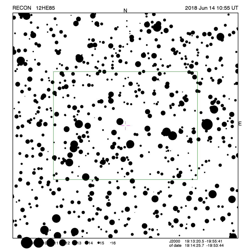
RECON: TNO occultation with 12HE85
Event between 12HE85 and star UC4-351-172422
with event index number of 129584
Geocentric closest approach at 2018/06/14 10:54:51 UTC
J2000 position of star is 19:13:20.5 -19:55:41
Equinox of date position of star is 19:14:21.7 -19:53:51
Stellar brightness R=15.6,
use SENSEUP=128
Star is 165 degrees from the moon.
Moon is 1% illuminated.
TNO apparent brightness V=26.2
 [RECON map]
TNO is 40.1 AU from the Sun
and 39.2 AU from the Earth.
The TNO is moving 21.8
km/sec on the sky relative to the star, or,
2.8 arcsec/hr.
The 1-sigma error in the time of the event is 2363 seconds.
The 1-sigma cross-track error in the shadow position is
5331 km.
The sky-plane scale is
28419.8 km/arcsec.
The TNO has an absolute magnitude Hv=10.1
Diameter=58.9 km assuming a 5% albedo -- 2.7 sec chord
Diameter=24.0 km assuming a 30% albedo -- 1.1 sec chord
Dynamical classification is CLASSICAL
Star training set for 12HE85, (2018/06/14 10:55UT)
Object            RA         Dec     mag  sep  mel
Antares        16:30:32.5 -26:28:17  0.9 38.07 156
Nunki          18:56:24.5 -26:16:20  2.0  7.60 168
PPM 235581     19:10:53.4 -19:46:23  6.4  0.84 166
PPM 269477     19:14:14.6 -20:23:22  8.2  0.50 165
PPM 235690     19:15:06.7 -19:53:35  9.2  0.16 165
12HE85         19:14:25.7 -19:53:44 15.6       165
Positions are for equinox of date
This table contains the target star visibility for the RECON
network. The observing range has been set to a maximum of
0.4 sigma about the mid-time.
The median site spacing is 21.7 km
RECON observability=0.5 and success probability=2.5%
| Site |
Site mid-time
(UT) |
Sun alt
(deg) |
Sky |
Moon |
Star alt
(deg) |
Star az
(deg) |
Target |
Observing Time
(UT) |
X-track
(km) |
| Oroville |
10:53:26 |
-7.9 |
CT |
Down |
19.2 |
198.2 |
Really Low |
10:38:26 - 11:08:26 |
5667 |
| Tonasket |
10:53:26 |
-8.1 |
CT |
Down |
19.5 |
198.2 |
Really Low |
10:38:26 - 11:08:26 |
5657 |
| Okanogan |
10:53:26 |
-8.4 |
CT |
Down |
19.8 |
198.1 |
Really Low |
10:38:26 - 11:08:26 |
5644 |
| Brewster |
10:53:26 |
-8.7 |
CT |
Down |
20.1 |
198.0 |
Low |
10:38:26 - 11:08:26 |
5635 |
| Manson/Chelan |
10:53:27 |
-9.0 |
CT |
Down |
20.4 |
197.6 |
Low |
10:38:27 - 11:08:27 |
5631 |
| Entiat |
10:53:27 |
-9.2 |
CT |
Down |
20.6 |
197.6 |
Low |
10:38:27 - 11:08:27 |
5621 |
| Wenatchee |
10:53:28 |
-9.4 |
CT |
Down |
20.9 |
197.5 |
Low |
10:38:28 - 11:08:28 |
5611 |
| Ellensburg |
10:53:28 |
-9.9 |
CT |
Down |
21.3 |
197.3 |
Low |
10:38:28 - 11:08:28 |
5595 |
| Yakima |
10:53:27 |
-10.2 |
CT |
Down |
21.7 |
197.4 |
Low |
10:38:27 - 11:08:27 |
5576 |
| Toppenish/White Swan |
10:53:27 |
-10.3 |
CT |
Down |
21.9 |
197.6 |
Low |
10:38:27 - 11:08:27 |
5563 |
| Goldendale |
10:53:28 |
-10.9 |
CT |
Down |
22.5 |
197.2 |
Low |
10:38:28 - 11:08:28 |
5543 |
| Pasco |
10:53:23 |
-9.8 |
CT |
Down |
21.7 |
198.8 |
Low |
10:38:23 - 11:08:23 |
5538 |
| The Dalles |
10:53:29 |
-11.2 |
CT |
Down |
22.8 |
196.9 |
Low |
10:38:29 - 11:08:29 |
5537 |
| George/Umatilla |
10:53:23 |
-10.2 |
CT |
Down |
22.1 |
198.6 |
Low |
10:38:23 - 11:08:23 |
5525 |
| PNWRO |
10:53:22 |
-9.9 |
CT |
Down |
21.9 |
199.1 |
Low |
10:38:22 - 11:08:22 |
5523 |
| Maupin |
10:53:28 |
-11.5 |
CT |
Down |
23.2 |
197.0 |
Low |
10:38:28 - 11:08:28 |
5515 |
| Madras/Culver |
10:53:28 |
-11.9 |
CT |
Down |
23.7 |
197.1 |
Low |
10:38:28 - 11:08:28 |
5488 |
| Sisters |
10:53:29 |
-12.4 |
AT |
Down |
24.1 |
196.6 |
Low |
10:38:29 - 11:08:29 |
5478 |
| Redmond |
10:53:28 |
-12.2 |
AT |
Down |
24.0 |
197.0 |
Low |
10:38:28 - 11:08:28 |
5471 |
| Bend |
10:53:28 |
-12.5 |
AT |
Down |
24.3 |
196.9 |
Low |
10:38:28 - 11:08:28 |
5462 |
| Oregon Observatory |
10:53:29 |
-12.7 |
AT |
Down |
24.5 |
196.8 |
Low |
10:38:29 - 11:08:29 |
5455 |
| La Pine/Gilchrist |
10:53:29 |
-12.9 |
AT |
Down |
24.7 |
196.8 |
Low |
10:38:29 - 11:08:29 |
5446 |
| North Lake |
10:53:26 |
-12.9 |
AT |
Down |
25.0 |
197.5 |
Low |
10:38:26 - 11:08:26 |
5414 |
| Chiloquin |
10:53:29 |
-13.9 |
AT |
Down |
25.8 |
196.6 |
Low |
10:38:29 - 11:08:29 |
5392 |
| Paisley |
10:53:24 |
-13.2 |
AT |
Down |
25.4 |
197.9 |
Low |
10:38:24 - 11:08:24 |
5378 |
| Klamath Falls |
10:53:28 |
-14.1 |
AT |
Down |
26.1 |
196.7 |
Low |
10:38:28 - 11:08:28 |
5372 |
| Tulelake |
10:53:27 |
-14.2 |
AT |
Down |
26.3 |
197.1 |
Low |
10:38:27 - 11:08:27 |
5352 |
| Lakeview |
10:53:23 |
-13.5 |
AT |
Down |
25.8 |
198.2 |
Low |
10:38:23 - 11:08:23 |
5348 |
| Cedarville |
10:53:22 |
-13.9 |
AT |
Down |
26.4 |
198.4 |
Low |
10:38:22 - 11:08:22 |
5308 |
| Fall River/Burney |
10:53:26 |
-14.9 |
AT |
Down |
27.2 |
197.3 |
Low |
10:38:26 - 11:08:26 |
5300 |
| Susanville |
10:53:23 |
-15.0 |
AT |
Down |
27.6 |
198.1 |
Low |
10:38:23 - 11:08:23 |
5253 |
| Greenville |
10:53:23 |
-15.3 |
AT |
Down |
27.9 |
197.9 |
Low |
10:38:23 - 11:08:23 |
5241 |
| Gimple |
10:53:24 |
-15.3 |
AT |
Down |
27.9 |
198.0 |
Low |
10:38:24 - 11:08:24 |
5240 |
| Quincy |
10:53:24 |
-15.5 |
AT |
Down |
28.1 |
197.9 |
Low |
10:38:24 - 11:08:24 |
5229 |
| Portola |
10:53:22 |
-15.4 |
AT |
Down |
28.1 |
198.4 |
Low |
10:38:22 - 11:08:22 |
5215 |
| Reno |
10:53:19 |
-15.2 |
AT |
Down |
28.2 |
199.1 |
Low |
10:38:19 - 11:08:19 |
5188 |
| Carson City |
10:53:18 |
-15.5 |
AT |
Down |
28.6 |
199.2 |
Low |
10:38:18 - 11:08:18 |
5166 |
| Gardnerville |
10:53:18 |
-15.7 |
AT |
Down |
28.8 |
199.3 |
Low |
10:38:18 - 11:08:18 |
5151 |
| Yerington |
10:53:17 |
-15.3 |
AT |
Down |
28.6 |
199.9 |
Low |
10:38:17 - 11:08:17 |
5144 |
| Hawthorne |
10:53:14 |
-15.4 |
AT |
Down |
28.9 |
200.5 |
Low |
10:38:14 - 11:08:14 |
5106 |
| Lee Vining |
10:53:15 |
-16.1 |
AT |
Down |
29.5 |
200.1 |
Low |
10:38:15 - 11:08:15 |
5081 |
| Tonopah |
10:53:09 |
-15.0 |
AT |
Down |
28.9 |
202.0 |
Low |
10:38:09 - 11:08:09 |
5053 |
| Bishop |
10:53:12 |
-16.1 |
AT |
Down |
29.9 |
201.0 |
Low |
10:38:12 - 11:08:12 |
5030 |
| Lone Pine |
10:53:11 |
-16.5 |
AT |
Down |
30.5 |
201.5 |
Up |
10:38:11 - 11:08:11 |
4975 |
| Beatty |
10:53:06 |
-15.6 |
AT |
Down |
29.9 |
202.7 |
Low |
10:38:06 - 11:08:06 |
4971 |
| Niwot |
10:52:30 |
-6.8 |
CT |
Down |
22.8 |
213.0 |
Low |
10:37:30 - 11:07:30 |
4938 |
| CPSLO |
10:53:20 |
-18.9 |
Dark |
Down |
32.5 |
199.0 |
Up |
10:38:20 - 11:08:20 |
4936 |
| Indian Springs |
10:53:02 |
-15.2 |
AT |
Down |
29.8 |
203.9 |
Low |
10:38:02 - 11:08:02 |
4929 |
| Henderson |
10:52:59 |
-15.2 |
AT |
Down |
30.1 |
204.7 |
Up |
10:37:59 - 11:07:59 |
4881 |
| Searchlight/Boulder City |
10:52:58 |
-15.6 |
AT |
Down |
30.6 |
204.9 |
Up |
10:37:58 - 11:07:58 |
4842 |
| Wildwood |
10:53:11 |
-18.7 |
Dark |
Down |
33.0 |
201.5 |
Up |
10:38:11 - 11:08:11 |
4819 |
| Patrick |
10:52:55 |
-15.0 |
AT |
Down |
30.3 |
206.0 |
Up |
10:37:55 - 11:07:55 |
4817 |
| Laughlin/Bullhead City |
10:52:57 |
-15.6 |
AT |
Down |
30.7 |
205.3 |
Up |
10:37:57 - 11:07:57 |
4814 |
| Kingman/Dolan Springs |
10:52:55 |
-15.3 |
AT |
Down |
30.5 |
205.8 |
Up |
10:37:55 - 11:07:55 |
4806 |
| Mohave Valley |
10:52:57 |
-15.8 |
AT |
Down |
31.0 |
205.4 |
Up |
10:37:57 - 11:07:57 |
4796 |
| DCO |
10:52:52 |
-14.8 |
AT |
Down |
30.3 |
206.8 |
Up |
10:37:52 - 11:07:52 |
4782 |
| Lake Havasu City |
10:52:55 |
-15.9 |
AT |
Down |
31.3 |
205.7 |
Up |
10:37:55 - 11:07:55 |
4763 |
| Idyllwild |
10:53:03 |
-17.9 |
AT |
Down |
32.8 |
203.5 |
Up |
10:38:03 - 11:08:03 |
4759 |
| Parker |
10:52:55 |
-16.2 |
AT |
Down |
31.6 |
205.9 |
Up |
10:37:55 - 11:07:55 |
4739 |
| Blythe |
10:52:55 |
-16.7 |
AT |
Down |
32.1 |
205.7 |
Up |
10:37:55 - 11:07:55 |
4708 |
| Calipatria |
10:52:59 |
-17.6 |
AT |
Down |
32.9 |
204.9 |
Up |
10:37:59 - 11:07:59 |
4693 |
| Yuma |
10:52:56 |
-17.4 |
AT |
Down |
33.0 |
205.9 |
Up |
10:37:56 - 11:07:56 |
4644 |
Azimuth is measured in degrees eastward from north.
North is at an azimuth of 0, due East is at an azimuth
of 90 degrees, due South is 180, and due West is 270.
Do not use the listing below for the RECON CPC 1100 telescopes.
This is provided for other non-team facilities.
Star training set for 12HE85, (2018/06/14 10:55UT)
Object            RA         Dec     mag  sep  mel
Antares        16:29:24.4 -26:25:55  0.9 38.07 156
Nunki          18:55:15.9 -26:17:49  2.0  7.60 168
PPM 235581     19:09:48.2 -19:48:15  6.4  0.84 166
PPM 269477     19:13:09.2 -20:25:19  8.2  0.50 165
PPM 235690     19:14:01.5 -19:55:33  9.2  0.16 165
12HE85         19:13:20.5 -19:55:41 15.6       165
Positions are for J2000
Event circumstances last updated at 2017/04/24 16:27:30 UT
Marc W. Buie,
Southwest Research Institute
RECON